This list includes both tools that Duke supports and tools that have been used by Duke digital projects. This is not an exhaustive list of tools available for use in digital humanities research. For a more extensive list of tools, check out the Carolina Digital Humanities Initiative tools webpage, Alan Liu's DH Resources for Building Projects site, or Miriam Posner's DH101 Resource Guide.

Agisoft PhotoScan is stand-alone software that produces 2-D elevation models and geometrically corrected aerial photos of a landscape and 3D models of an object by performing the photogrammetric process on many digital images. Find help using tool at Duke: No Agisoft Tutorials Page Stage(s) in… read more » about Agisoft Photoscan
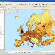
ArcGIS Desktop is a foundational piece for GIS professionals to create, analyze, manage, and share geographic information so decision-makers can make intelligent, informed decisions. It allows you to create maps, perform spatial analysis, and manage data. You can import multiple data formats and use powerful analytical tools and workflows to identify spatial patterns, trends, and non-obvious… read more » about ArcGIS Desktop
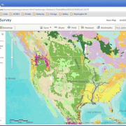
Arc Online is a proprietary cloud-based application for creating, sharing, and mapping data. The application provides built in maps and spatial analysis tools, as well as features for embedding these maps and analysis into narrative-like form. Find help using tool at Duke: Yes Duke Libraries LibGuide… read more » about ArcGIS Online

"CARTO is the platform for turning location data into business outcomes." It is a leading Location Intelligence platform, enabling organizations to use spatial data and analysis for more efficient delivery routes, better behavioral marketing, strategic store placements, and much more. Find help using tool at Duke: Yes Carto… read more » about Carto

DH Press is a flexible, repurposable, extensible digital humanities toolkit designed for non-technical users as a plugin for the Wordpress CMS. It enables administrative users to mashup and visualize a variety of digitized humanities-related material, including historical maps, images, manuscripts, and multimedia content. DH Press can be used to create a range of digital projects, from virtual… read more » about DH Press
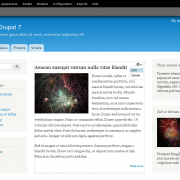
Drupal is content management software. It's used to make many of the websites and applications you use every day. Drupal has great standard features, like easy content authoring, reliable performance, and excellent security. But what sets it apart is its flexibility; modularity is one of its core principles. Its tools help you build the versatile, structured content that dynamic web experiences… read more » about Drupal

Kits allows Duke faculty, students and staff to create and define online communities or groups and then control access and rights to various online tools, such as Duke WordPress, Sakai, Sympa email lists, Duke Video and wikis in Confluence. Find help using tool at Duke: Yes Duke Kits Website Stage(s) in research process to use tool… read more » about Duke Kits

GeoNode is a web-based application for uploading and sharing geospatial files like data files with latittude and longitude coordinates and georectified historical maps. GeoNode allows one to browse and search for geospatial data; upload, manage, and share geospatial data; create and share interactive maps; and collaborate and interact with other users. Find help using… read more » about GeoNode
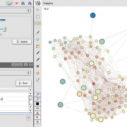
Gephi is a tool to explore data and create graphs and networks. Like Photoshop but for graph data, the user interacts with the representation, manipulate the structures, shapes and colors to reveal hidden patterns. The goal is to help data analysts to make hypothesis, intuitively discover patterns, isolate structure singularities or faults during data sourcing. Find help using tool at Duke:… read more » about Gephi

Google My Maps is a free tool that allows users, from one to many, to design and publish customized maps. You can easily create custom maps with the places that matter to you; allow others to see and edit your maps, or publish them to the world; and view custom maps in the Google Maps mobile app so you can find places on the go. Find help using tool at Duke: Yes… read more » about Google My Maps
Juxta Editions is a professional editing suite for the creation of digital scholarly editions. It provides assistance during the entire process of preparing a digital edition, from transcribing texts to editing and annotating them, to publishing online. Find help using tool at Duke: No Juxta Editions Stage(s) in research process… read more » about Juxta Editions

Lentil is an application for harvesting and displaying images and videos from Instagram based on hashtags. The application creates a website containing images and videos with specified hashtag(s), and also provides the ability to download these images and videos and any information about them. Find help using tool at Duke: Yes… read more » about Lentil

Mapbox is a subscription-based web mapping platform. The platform can be used to store, share, and geolocate data, as well as create interactive and time-based maps that can be easily embedded into a website. Find help using tool at Duke: No Mapbox Help Page Stage(s) in research process to use tool: analysis;… read more » about MapBox

Neatline allows scholars, students, and curators to tell stories with maps and timelines. As a suite of add-on tools for Omeka, it opens new possibilities for hand-crafted, interactive spatial and temporal interpretation. Neatline allows scholars, students, and curators to tell stories with maps and timelines. Find help using tool at Duke: Yes… read more » about Neatline

Omeka is a free, flexible, and open source web-publishing platform for the online display and curation of visual collections and exhibitions (i.e. library, museum, archives, and scholarly collections and exhibitions). Great tool for projects utilizing visual images, physical objects, and material culture items. Find help using tool at Duke: Yes… read more » about Omeka
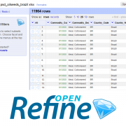
OpenRefine (formerly Google Refine) is a powerful tool for working with messy data: cleaning it; transforming it from one format into another; and extending it with web services and external data. OpenRefine can be used to scrape data from websites or convert data between formats. It also makes it easy to save the processing steps to a file that can be… read more » about OpenRefine

Qgis is desktop software for performing geospatial analysis. The application can be used to explore such things as the distribution of information on a map and overlaying historical maps on modern maps. Find help using tool at Duke: Yes Duke Libraries LibGuide… read more » about QGIS

Shiny is an open source R package that provides an elegant and powerful web framework for building web applications using R. Shiny helps you turn your analyses into interactive web applications without requiring HTML, CSS, or JavaScript knowledge Find help using tool at Duke: Yes… read more » about R Shiny
Scalar is a free, open source authoring and publishing platform that’s designed to make it easy for authors to write long-form, born-digital scholarship online. Scalar enables users to assemble media from multiple sources and juxtapose them with their own writing in a variety of ways, with minimal technical expertise required. More fundamentally, Scalar is a semantic web authoring tool that… read more » about Scalar
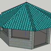
SketchUp is a free 3D modeling software that is both powerful and easy to learn. It is best applied in architectural (historical or contemporary) contexts. SketchUp also includes a number of other paid versions for desktop and web. Find help using tool at Duke: Yes Wired! Lab SketchUp Tutorials… read more » about SketchUp

Social Feed Manger is an application for harvesting tweets by Twitter users and hashtags. The application creates downloadable spreadsheets of tweets that can be used to do text analysis or mapping projects. Find help using tool at Duke: Yes Social Feed Manager Documentation Stage(s) in research… read more » about Social Feed Manager
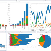
Tableau Software helps people see and understand data. Tableau helps anyone quickly analyze, visualize and share information. Tableau can predict the best visualization for your dataset and provides many different types of visualizations, from charts and tree graphs to geospatial maps. Find help using tool at Duke: Yes … read more » about Tableau
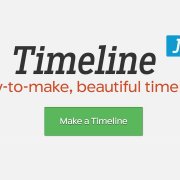
TimelineJS is an open-source tool that enables anyone to build visually rich, interactive timelines. Beginners can create a timeline using nothing more than a Google spreadsheet; experts can use their JSON skills to create custom installations, while keeping TimelineJS's core functionality. Find help using tool at Duke: Yes … read more » about TimelineJS

Software for presenting scanned books. Turning the Pages is leading digital facsimile software to show rare books and manuscripts in-gallery and online. Turning the Pages is now available in 4K Ultra High Definition, making it possible to display books and manuscripts at a whole new level of detail. Find help using tool at Duke: No… read more » about Turning the Pages

Unity 3D is game-design engine used to develop video games and simulations. It has different versions, including Unity Pro and Unity Plus. The product is created by Unity, the world's leading platform for creating and operating interactive, real-time 3D (RT3D) content. Find help using tool at Duke: Yes Unity 3D Stage(s) in research… read more » about Unity 3D

The Versioning Machine is a framework and an interface for displaying multiple versions of text encoded according to the Text Encoding Initiative (TEI) Guidelines, and is P5 compatible. While the VM provides for features typically found in critical editions, such as annotation and introductory material, it also takes advantage of the opportunities afforded by electronic publication to allow for… read more » about Versioning Machine
Voyant Tools is a web-based text reading and analysis environment. It is a scholarly project that is designed to facilitate reading and interpretive practices for digital humanities students and scholars as well as for the general public. Find help using tool at Duke: Yes Data and… read more » about Voyant
WordPress is web software you can use to create a beautiful website, blog, or app. WordPress started as just a blogging system, but has evolved to be used as full content management system and so much more through the thousands of plugins and widgets and themes. Find help using tool… read more » about WordPress